
This indicator tracks the frequency, extent, and severity of wildfires in the United States.
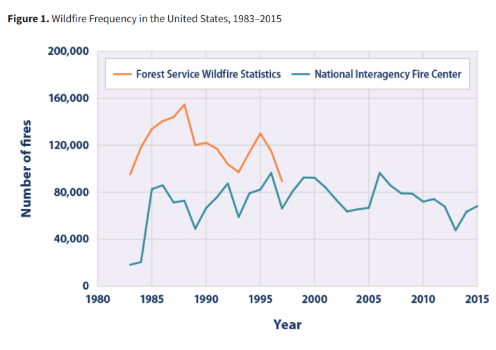
This indicator defines wildfires as “unplanned, unwanted wildland fire[s]” in forests, shrubland, and grassland, where “the objective is to put the fire out.”9 This indicator tracks three aspects of wildfires over time: the total number of fires (frequency), the total land area burned (extent), and the degree of damage that fires cause to the landscape (severity). The total area and total number of fires are tracked by the National Interagency Fire Center, which compiles reports from local, state, and federal agencies that are involved in fighting wildfires. The U.S. Forest Service tracked similar data using a different reporting system until 1997. Those data have been added to this indicator for comparison. Wildfire severity is measured by comparing the “greenness” of satellite images taken before and after a fire to classify how severely the land has been burned. Burn severity provides an indication of the ecological damage and how long the effects of wildfires are likely to last.
Although some nationwide fire data have been collected since the early 1900s, this indicator starts in 1983 (Figures 1 and 2) and 1984 (Figures 3, 4, and 5), when nationwide data collection became more complete and standardized.
