

Environmental Protection Agency: A Closer Look - Land Loss Along the Atlantic Coast

This feature provides a closer look at one consequence of sea level rise along the Atlantic coast: the conversion of land to open water.
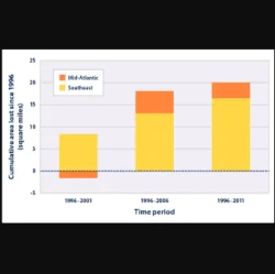
Measurements of the change in coastal land depend on land cover and elevation data, which have significant limits in terms of accuracy and precision. Some results are field-checked for accuracy. The coastal land cover data are routinely compiled by the National Oceanic and Atmospheric Administration’s Coastal Change Analysis Program, and they represent the federal government’s most comprehensive set of data on land use and land cover in the coastal zone.
Sea level rise is not the only factor that contributes to the loss of coastal land. In addition to the natural sinking of the shoreline in some areas, such as the Mid-Atlantic, coastal land loss has been made worse by human activities such as navigation and flood control structures that block wetland migration or the movement of sediment; withdrawal of ground water, oil, or natural gas in some regions; and boat traffic that accelerates wetland erosion.4 Natural processes unrelated to current sea level rise can also cause shores to erode.