
This indicator measures water levels and surface water temperatures in the Great Lakes.
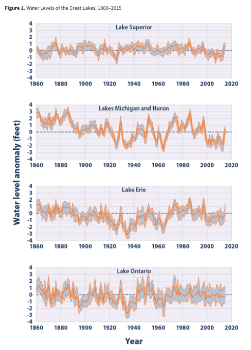
This indicator analyzes water levels and surface water temperatures in the Great Lakes. Water levels are recorded by gauges along the shore of each lake, some of which have been operated since the 1800s. Pre-1918 data came from one water level gauge per lake. Data since 1918 have come from a designated set of gauges in each lake. Figure 1 shows annual water level anomalies, or differences, in feet compared with the average water levels in each lake from 1860 to 2015. Lakes Michigan and Huron are combined because they are connected at the same water level.
Surface water temperatures are measured by satellites. Figure 2 shows annual average temperatures over the entire surface of each lake, along with the pattern of daily temperatures over the course of the year. This figure’s data begin in 1995, which was the first year with complete satellite data for all five lakes.
