
On this page:
- Components of a Source Water Program
- Drinking Water Mapping Application to Protect Source Waters (DWMAPS)
Components of a Source Water Protection Program
The primary objective of a source water protection program is to safeguard and improve source water quality for current and future use. A program may include several fundamental components, such as:
- An inventory and characterization of the contaminant threads in the source water protection area;
- An action plan outlining strategies and resources required for the long-term management of the source to prevent contamination; and
- Implementation of the management measures identified in the planning process.
When developing a program, partners should account for a variety of factors such as local environmental conditions, the needs and capacity of water providers, stakeholder interests, and other site-specific factors.
Utilities and other source water protection partners can take the following steps to develop and implement a source water protection program. This process is adapted from the Source Water Assessment Program requirements authorized by the 1996 Amendments to the Safe Drinking Water Act.
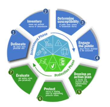
Assessment Phase
Step 1 – Delineate the source water protection area (SWPA).
A source water protection plan includes a delineated area that shows the area to be assessed and protected based on where the public water system draws drinking water supplies.
Step 2 – Inventory known and potential sources of contamination.
A contaminant source inventory lists all documented and potential contaminant sources or activities of concern within the SWPA that may pose a threat to drinking water supplies.
Step 3 – Determine the susceptibility of the public water system to contaminant sources or activities within the SWPA.
Determining the susceptibility of the public water system to threats included on the contaminant source inventory list is an important step for connecting the nature and severity of the threat to the likelihood of the threat contaminating source water.
Step 4 – Engage the public about threats identified in the assessment.
Effective source water protection programs ensure that the public has the information necessary to act to prevent contamination. Early involvement in the planning process helps build consensus on the need for action, leading to more comprehensive source water protection.
Protection Phase
Step 5—Develop an action plan to identify and prioritize specific implementation activities.
Communities can use the information gathered from the source water assessment process to develop action plans identifying long-term management strategies for preventing contamination of sources of drinking water.
Step 6 – Protect source of drinking water by implementing protective actions.
Communities use many different source water protection practices to prevent contamination of their drinking water supplies. These measures can be tailored to address each threat or an array of risks specific to each public water system.
Step 7 – Evaluate and update action plan periodically.
Plans should be evaluated and, if necessary, revised in response to new information, such as changes to the watershed or source water protection area or other factors that could affect the relevance and efficacy of the plan.
Drinking Water Mapping Application to Protect Source Waters (DWMAPS)
The Drinking Water Mapping Application to Protect Source Waters (DWMAPS) is an online mapping tool for source water assessment and planning. Use this tool to locate potential sources of contamination to your drinking water source and gather data to support source water assessments and inform development of source water protection and emergency response plans. DWMAPS provides layers of spatially referenced data using information from environmental databases, such as the Safe Drinking Water Information System (SDWIS), the National Pollution Discharge Elimination System (NPDES), Toxic Release Inventory (TRI), Enforcement and Compliance Online (ECHO), and the Resource Conservation and Recovery Act Information (RCRAInfo).
DWMAPS enables users to:
- Identify potential sources of contamination upstream of locations defined by users;
- Learn which watersheds supply public drinking water providers;
- Locate drinking water provider service areas by county;
- Overlay data from the desktop or thousands of public online sources with source water protection layers;
- Locate watershed restoration projects and source water protection partnerships;
- Build and print maps in multiple formats.
