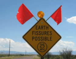
Earth fissures are open surface fractures that may be up to a mile in length, up to 15 ft wide, and 10s of feet deep.
Earth fissure hazard data are currently unavailable for tribal lands in Arizona. To assess earth fissure hazards on tribal lands, please seek out further information from the appropriate Tribal Division of Public Safety Department or Environmental Protection.
Mitigation Tips
Earth fissures occur in areas of extensive ground subsidence as a result of groundwater withdrawal. As the ground subsides unevenly, stress along the basin margins lead to earth fissure formation. Counties in Arizona host earth fissures, include, Cochise, La Paz, Maricopa, Pima and Pinal County.
Earth fissures can damage infrastructure (utility lines, roads, canals, etc.) and buildings, alter flood and drainage patterns, and pose a health hazard to people and livestock. Additionally, earth fissures are a direct path to the groundwater table, so pollutants and contaminants could potentially flush down the fissure into a groundwater aquifer. Earth fissures are a long-term problem and may well continue to form should subsidence continue unchecked.
Reducing the occurrence of earth fissures and their associated impacts is a community effort.
UTILITIES, PUBLIC WORKS, AND TRANSPORTATION
- Lessen dependence on groundwater by using alternative sources;
- Be aware of where fissures are located and avoid building infrastructure through, on, or over them;
- Avoid routing drainage into fissures: watering fissures makes them grow;
- Ensure alternate emergency routes exist where fissures cross existing roads; and
- Monitor storm and sewage drains for flow reversal.
PLANNING AND ZONING
- Encourage developers to avoid fissure-prone areas;
- Require a minimum setback for buildings/infrastructure in fissure areas; and
- Prohibit residential zones in fissure areas.
HOMEOWNERS
- Familiarize yourself about fissures before buying property in fissure-prone areas;
- Carefully read the disclosure before buying; and
- Fence off the fissure to keep animals and children out.
EVERYONE
- Practice smart water conservation – even if you don’t live in a fissure-prone areas, your water consumption may be contributing to the fissure formation in other areas;
- Do NOT dump garbage, appliances, manure, or other contaminants into fissures; and
- If you see something you suspect is a fissure, report it to the Arizona Geological Survey
Further Reading
Earth fissures are open surface fractures that may be as much as a mile in length, up to 15 ft wide, and 10s of feet deep. In Arizona, earth fissures form as a result of land subsidence driven by groundwater withdrawal. The Arizona Geological Survey has mapped and reported earth fissures throughout south-central and southeastern Arizona since the 1990s and published earth fissure study area maps in accordance with Arizona Revised Statute § 27-152.01(3) since 2007. Mapping of fissures involves incorporating mapped earth fissures from previous studies, examining remotely sensed subsidence data and aerial imagery, and on-site field mapping using high-precision GPS receivers.
Between 2007 and 2017, AZGS identified 27 earth fissure study areas throughout southern and central Arizona with concentrations of earth fissures totaling more than 150 miles of mapped fissures. These include uninterrupted open fissures, fissure gullies, and discontinuous linear trends of potholes, abbreviated open cracks, elongated depressions, and other collapse features. An additional 180 miles of reported/unconfirmed earth fissures appear on AZGS maps. These features include fissures previously mapped by professional geologists that appear in published maps or figures but could not be confirmed through recent surface mapping by AZGS geologists.
A reasonable effort was made to identify all earth fissures in the study area although some fissures may remain unmapped due to overprinting or disturbance by development, agricultural tilling, or lack of surface expression along the fissure at the time of mapping. Earth fissures are not static features. They may change in width, depth or length, and new fissures may appear after an area has been mapped. For these reasons the State of Arizona does not guarantee the maps are error free. Blank areas within study area boundaries have been investigated and no surface evidence of fissures was found as of the date of map publication.
For additional information on the origin and impacts of earth fissures see ‘Land Subsidence and Earth Fissures in Arizona’ by Steve Slaff.
GIS Earth Fissure Data: Locations of Earth Fissure Traces in Arizona v. 06.01.2019
Related information


