
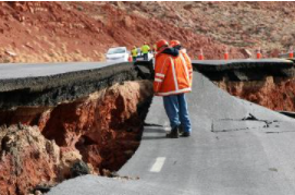
Landslides in Arizona destroy homes, damage roads, disrupt utilities and infrastructure, and lead to deaths and injuries.
Landslides in Arizona
Landslides in Arizona are common; far more common than most people think. ‘Landslide’ is a generic term referring to the downslope movement of rock, soil, and detritus driven by gravity. Landslides frequently start on the moderate to steep slopes of Arizona’s mountains, plateaus, mesas, and buttes before spilling out into her canyons and valley floors. In the U.S., landslides rival floods as the deadliest and costliest natural hazard, causing dozens of fatalities and ~$2–3 billions of damage to infrastructure, roads, buildings and homes annually (Source: NOAA National Weather Service Flood Loss Data,https://www.nws.noaa.gov/oh/2019NHA.html).
Landslide Facts
- Landslide features appear on the Natural Hazards in Arizona Viewer
- More than 6,000 landslide features are identified in Arizona
- Landslides velocities range from in/yr to miles/hr
- Landslides occur in all 15 Arizona Counties
- ~ 50% of landslides occur on Tribal Lands
Landslide Types
A wide array of landslides occur in Arizona. Ranging from fast-moving debris flows, rockfall, and topple to slow-moving creep, and from larger volume rotational landslides and debris avalanches to smaller volume earthflow. Landslides result from disturbances in the natural stability of a slope. Frequently, they accompany heavy rains, earthquakes, or volcanic eruptions.
Principally associated with mountainous areas, landslides can occur in areas of low relief, as well. Common landslide triggers include heavy rain, rapid snow melt, earthquakes, volcanic eruptions, and freeze and thaw cycle. Channelized debris-flows are common in Arizona’s mountains and frequently accompany intense rainfall. Flows may occur hours after the period of the heaviest rain in a storm and miles from the storm center.

Landslide Snapshot Video
Photographs of recent landslide deposits in Arizona.
