
KARST – kärst. An irregular limestone region with sinkholes, underground streams, and caverns; Noun, earliest use 1902 German, from Slovene dialect or Croatian dialect kras, kars, type of rock, region composed of such rock (Source: Merriam-Webster)
CaCO3 + H+ + HCO3– —–> Ca2+ + 2HCO3–
OR
calcite + hydrogen ions + bicarbonate —–> calcium ions + bicarbonate
Karst in the United States.
Karst features and landscapes occur where rocks prone to dissolution by weakly acidic natural waters occur at Earth’s surface or in the shallow subsurface. This includes rocks such as limestones, marbles, dolostones, gypsum and rock salt. In the United States, fully 1/5th of the surface area displays karst features. Twenty states, including Florida, Missouri, and Kentucky, are dominated by karst landscapes. Missouri has more than 6,000 known karst caverns and caves. Common karst features include sinkholes, collapse pits, disappearing streams, swallets, and caves. The U.S. Geological Survey used geologic maps products of state geological surveys, including AZGS, to compile a nationwide map showing areas of karst or potential karst or pseudokarst development (Weary and Doctor, 2014). The image below, ‘Karst in Arizona‘, stems from that map compilation. Areas mantled in dark blue represent dryer, less humid, lower elevation environments; turquoise mantling reflects wetter, more humid, higher elevation environments.
Karst in Arizona. In Arizona karst landscapes and features are common and occur in the state’s three physiographic regions: Colorado Plateau, Transition Zone, and the Basin and Range Province. On northern Arizona’s Colorado Plateau the Permian Kaibab Formation, a karstic limestone, is prevalent at the surface and in the shallow subsurface.
1.jpg)
The graphic above shows karst areas identified in Arizona – most occur in Pennsylvanian and Permian-age carbonates. For the complete document – KML file, GIS data and report of “Karst in the United States: A Digital Map Compilation and Database”. For select pictures of prominent karst features of Arizona page down to From the AZGS Photo Library.
Paleokarst features are abundant in the buried Mississippian Redwall limestone. Collapse of overlying strata (i.e., overburden) into paleokarst caverns of the Redwall limestone drives the formation of fresh karstic features, e.g., the Devil’s Kitchen sinkhole near Sedona (Lindberg, 2010). The breccia pipes of northern Arizona formed when overburden comprising Mesozoic- and Paleozoic-age rock (Permian and Pennsylvanian)- collapsed into the Redwall Limestone roughly between 200 my and 260 my ago.
AZGS’ Bibliography of Arizona Geology (AZGeoBib) is an excellent source of karst literature in Arizona. AZGeoBib comprises more than 13,000 citations of geologic and geohydrology research. A search of the database for ‘karst’ identifies 70 citations of research papers published between 1902 and 2002. (Note: the bibliography of Arizona Geology has not been updated since the early 2000s, so more recent papers are not included.)
Economic Benefits of Karst to Arizona: Recreational Caves, Karst Aquifers and Breccia Pipes
Karst Caves for Tourists and Recreational Cavers. Caves are among the most common of karst features and people flock to them for an otherworldly experience. Dissolution of soluble rocks (limestones, dolostones, and marble) can produce open caverns that abound in stunning products of stalactites, stalagmites, drapery formations (curtains), capillary tubes (hollow stalactites), columns, flowstone, and less commonly, helictites.
Caves of note in Arizona, in part because of their accessibility, include: Kartchner Caverns in Kartchner Cavern State Park, south of Benson, Arizona; Colossal Cave in Colossal Cave Mountain Park, Pima County; Cave of the Bells in the Coronado National Forest, Santa Rita Mountains; Grand Canyon Caverns east of Peach Springs, Arizona; Peppersauce Cave in the Santa Catalina Mountains, near Oracle, Arizona.
Botanist/biologist Robert Pape and his colleagues host an authoritative website, ‘Kartchner Caverns Macro-invertebrate Research Project‘ on animals inhabiting Kartchner Caverns in the Whetstone Mountains of eastern Cochise County.
The Bibliography of Arizona Geology includes 108 citations related to cave geology, ecology or environment. You can review those citations here.
CAVEAT. Caves are surprisingly fragile and potentially dangerous environments. There are thousands of caves in Arizona, only a few are well-explored, well-known, and monitored regularly. Please partner with experienced cavers carrying multiple light sources when exploring a cave. Caves are inherently dangerous, so take all due precautions for the safety of you and your team. The National Speleological Society provides “A Guide to Responsible Caving” to assist cavers – new and experienced – in appropriate caving safety and etiquette.
Karst Aquifers. Karstic rocks of northern and central Arizona include important aquifers — sources of accessible groundwater. In northern Arizona, the C aquifer, comprising the karstic Kaibab Limestone, Coconino Sandstone, and the upper and middle Supai Formation, is an important source of water. In central Arizona’s Verde Valley, the cavernous Mississippian Redwall Limestone is a major aquifer and an important source of water for Sedona and other nearby communities. There are other karstic aquifers in Arizona, but few rival the C aquifer and Redwall in areal extent or productivity.
Breccia Pipes. Northern Arizona and southern Utah are home to thousands of breccia pipes; solution-collapse pipes that measure hundreds of feet in diameter comprising broken and angular rock fragments drawn largely from sedimentary rocks of Triassic, Permian, and Pennsylvanian age. The pipes bottom out in paleokarst caverns of the Mississippian-age Redwall Limestone hundreds to thousands of feet below the surface. A small percent of breccia pipes are mineralized (Wenrich and Sutphin, 1988). In the late 19th and early-to-mid 20th century, prospectors mined copper, silver, lead and zinc from mineralized pipes. Some mineralized breccia pipes contain up to 1 percent U3O8, making those pipes a prime target for uranium mining for use in nuclear technology – fuel for nuclear power plants, weaponry, and nuclear medicine – since the 1950s.
A surge in the price of uranium in 2006-2007 precipitated a uranium land rush in Arizona’s breccia pipe province. Exploration faltered in the face of falling uranium prices and was temporarily checked in 2012 by the Obama Administration’s 20-year moratorium on mining claims in the vicinity of Grand Canyon National Park and along the Arizona Strip.
Geologic Hazards of Karst Areas
From A Home Buyer’s Guide to Geologic Hazards in Arizona. “Hazards from karst include the formation of sinkholes or collapse pits, as well as cracking of walls, foundations, roads, and other structures. Less obvious but equally important are the impacts karst can have on water quality. Networks of interconnected caverns and voids allow contaminants such as sewage, landfill leachate, or hazardous chemicals to travel unimpeded into shallow aquifers that may supply drinking water. The possible presence of solution features must be carefully considered when making land-management decisions, including protecting water supply, locating septic systems, and siting of waste disposal facilities.”
For a fuller treatment of karst hazards see the Karst Hazards section of Ray Harris’ (2002) “A review and bibliography of Karst Features of the Colorado Plateau, Arizona”. This report includes a map of the principal karst area of Arizona’s Colorado Plateau, as well as numerous black & white photos of karst features, including open fractures and sinkholes.
Select Karst Features in Central and Northern Arizona
McCauley Sinks. The McCauley Sinks comprise several dozen small sinkholes restricted to a 1.85 mile-wide depression. The sinks are arranged in a series of gentle arcs or rings. The size of individual sinks varies, but large sinks are ~ 300 ft in diameter and up to 160 ft deep. The sinks crop out in limestone of the Permian Kaibab Formation. Collapse here may be the result of buried karst formations in the older Permian Schnebly Hill Formation, which contains evaporites, principally halite (rock salt) (Neal and Johnson, 2002). Slow subsidence at some sinkholes is an ongoing process (Brian Conway, pers. comm, ca. 2015).
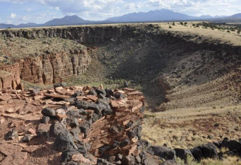
Sedona Devils Kitchen Sinkhole. One of the earliest descriptions of Devil’s Kitchen, which involved a collapse event there, was retold by long-term resident Albert E. Thompson (1968), “My parents were living in Sedona in the early1880s and heard the crash when the spot caved in. Mother said the dust from the cave-in filled the air all day and the sun looked like it was shining through heavy smoke. Her brother, Jim James, was the first one to see the new hole in the ground”.
In late 1989, a second historic collapse event occurred at Devils Kitchen, enlarging the opening by as much as 1/3rd. The 1989 event was largely limited to the north wall, where a gigantic block, detached along three bounding walls from its caprock, rotated outward into the opening without dropping to a lower elevation. Edges of the newly broken rocks are highly angular and the surface soil has not yet begun to slough off.
Collapse of the southernmost wall of the sinkhole predated historic collapse events and probably represents an early, formative event in the history of Devils Kitchen. In contrast to the fresh, angular appearance of historically broken blocks, blocks of the south wall display rounded edges and the surfaces carry a patina of manganese oxide that suggests open exposure over several hundred years. The Devil’s Kitchen is one at least seven sinkholes in the Sedona area (Lindberg, 2010b.)
