
Arizona has earthquakes; seismologists like to say, “Earthquakes don’t kill people, buildings kill people”
Earthquakes threaten Arizona
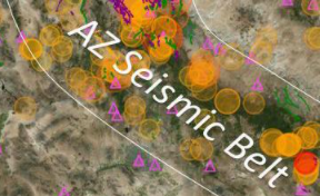
Arizona has earthquakes! Each year hundreds of unfelt and several felt earthquakes occur in Arizona (see the graphic to the right for felt 3+ magnitude earthquakes). The Arizona Geological Survey maintains an active catalogue of earthquake activity that includes events recorded by the Arizona Broadband Seismic Network.
Some recent Arizona earthquakes
- 1887 Sonoran Earthquake – A M7.6 earthquake on the Pitaycachi fault near the Arizona -Mexico border, south of Douglas killed nearly 60 people and was felt widely throughout the Southwest, including: Tucson, Bisbee, Yuma, Phoenix, Prescott, Albuquerque, El Paso, and Sonora, Mexico.
- 1906, 1910, 1912 – Flagstaff Area, 3 moderate-sized earthquakes (magnitude range from M6.0 to M6.2) rattled Flagstaff at the turn of the 20th century. These events were widely felt throughout northern Arizona.
- 1976 Prescott/Chino Valley Earthquake – An M5.0 earthquake occurred near Prescott, AZ.
- 1993 Cataract Creek Earthquake Sequence – Several earthquakes occurred in a swarm of events that included an M5.4 and M5.0 near Valle, just south of the South Rim, Grand Canyon, AZ.
- Most recent felt events, include: 2005 M5.2 near Holbrook; 2014 M5.3 near Duncan; 2015 M4.1 near Black Canyon City, AZ. The latter shook Phoenix and was felt by perhaps millions of people.
Timelapse video: Historic earthquake epicenters of Arizona
Arizona Earthquakes
Earthquakes in Arizonado not occur as frequently as they do in neighboring California, Nevada and Utah, but hundreds of earthquakes occur each year in Arizona. Most of these earthquakes go unfelt. But every 5-10 years a moderate-sized earthquakes remind us of the potential for larger, more destructive events. Over the last decade, the AZGS has improved seismic monitoring throughout the state and we are now capable of detecting in-state earthquakes with a Magnitude 3.0 or larger. Most of the earthquake activity is located within 5-10 miles of known faults. Arizona earthquakes generally occur within a swath from the north-northwestern to the southeastern part of the state.
Where and why do earthquakes occur? – Earthquakes occur in areas where the crust of the Earth is under stress from plate tectonics. Over time, buildup of stresses exceed the strength of the rocks undergoing the stress and they break. This break in the rock is called a fault. The resultant energy released from the breaking of the rocks is an earthquake. Most of the earthquakes in Arizona occur near 10km depth or deeper, and do not release enough energy to break the ground-surface.
The majority of Arizona’s earthquake activity occurs in the northern part of Arizona, although there are areas such the southeastern (Safford, Duncan, Tucson), southwestern (Yuma) and central mountain region (Prescott, Mayer, Holbrook) of the state that experience significant earthquake activity. There is a distinct seismic belt that runs from the north-northwestern to the southeastern part of the state, the Arizona Seismic Belt. In this belt, there have been multiple events above M3.0 with an M5.0 occurring nearly every 10 years or so.
Earthquake faults are fractures below and at the land surface that have evidence of rock, sediment and or soil offsets. If large enough (greater than about M6.3), earthquakes will disrupt the land surface. There are approximately 100 faults known to be active within Arizona’s borders. Even when fault ruptures do not make it to land surface, the ground-shaking from subsurface rupture can still cause substantial damage.
Impacts on People, Property & Infrastructure
Seismologists like to say, “Earthquakes don’t kill people, buildings kill people.” And that is about right, if not entirely correct. Cascading events, events caused by ground shaking, such as landslides, collapsing bridges, roads, and dams, falling objects, tsunami, and fire, kill people, too. But the chief earthquake hazard for people living in Arizona is from building collapse or falling objects: indoor hazards include heavy bookcases, pictures, appliances, and large screen TVs; while outdoors, parapets, masonry, adornments, cornices, rain gutters, lights, and ornamental gargoyles constitute a hazard.
In the event of an earthquake, which will strike suddenly and without warning, Benjamin Franklin was spot-on, ‘an ounce of prevention is worth a pound of cure.’ Here are some tips to help you, your family, business and community mitigate injury and damage from the ground shaking that accompanies earthquakes.
- Follow the Seven Steps approach to earthquake preparedness (7-Steps – p 11)
- 7 Steps to a Disaster Resilient Workplace (EQ Country Alliance)
- Practice ‘Drop, Cover & Hold On’ – Great Arizona Shakeout
- Make a Plan (Ready.gov)
- Be proactive – prepare!
Geoscience at Work for Arizona
Where and when will the next major earthquake occur in Arizona? How much damage will it do? Will people be injured?
We cannot answer those questions today, but working with geoscientists at Northern Arizona University (NAU), the AZGS has built and maintains a statewide seismic monitoring network to record earthquakes and to look for patterns of seismic activity. In 2017, the Arizona Broadband Seismic Network (ABSN) was expanded from 8 to 13 stations, strategically located to provide statewide coverage and to capture more of the seismicity throughout Arizona. Working with NAU and the US Geological Survey, we have compiled a catalog of more than 3,000 historic seismic events (1852 – 2017).
The Arizona Earthquake Information Center (AEIC), headquartered at Northern Arizona University, was launched and operated for decades by Dr. David Brumbaugh. Currently, efforts are underway to include the AZGS in the operation of the AEIC so that Drs. Jeri Y Ben-Horin and Dave Brumbaugh can jointly run the AEIC.
Hazard Communication A chief objective is to communicate the impact of earthquake hazards and risk to the Arizona public and their representatives at the municipal, county, tribal, state, and federal level. Each year, AZGS partners with the Arizona Dept. of Emergency Management and Military Affairs and County and municipal emergency managers to host the Great Arizona ShakeOut earthquake preparedness exercise.
In the event of moderate or severe ground shaking, ‘Drop, Cover and Hold on‘.
Glossary of Terms
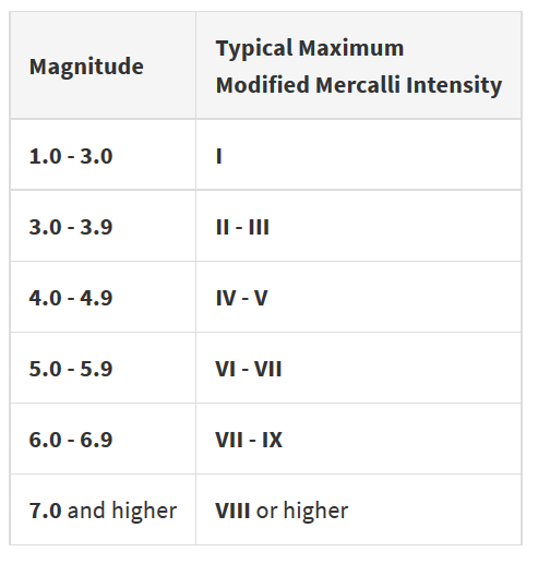
Magnitude is measure of the energy released during fault rupture.
Intensity is determined from effects on people, human structures, and the natural environment.
Faults are planes of weakness in the Earth’s crust. Movement of rocks on either side of the fault generates earthquakes.
Modified Mercalli Scale is a scale of 1 to 12 (expressed in Roman numerals) illustrating the impact of an earthquake on society.
Resources
PUBLIC
GEOTECHNICAL
GEOSURVEYS
DOCUMENTS
Interactive map highlights fissures, floods, fires, earthquakes, and fault lines in Arizona.

